How Does the Equator Shape Global Climate?
The equator, a geographical term, refers to the line of longest circumference along the path of Earth's rotation. Its radius is 6,378.2 km and its circumference is 40,075.02 km.
The equator is the dividing line between the Northern and Southern Hemispheres, dividing the Earth into the Northern and Southern Hemispheres to the north and the Southern Hemisphere to the south. It serves as the baseline for latitude. The equator has a latitude of 0° and is the longest line of latitude on Earth. It is also the point on Earth where the acceleration due to gravity is the lowest.
Basic Overview
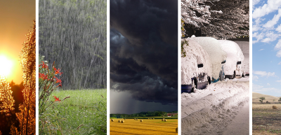
- The equator is the dividing line between the Northern and Southern Hemispheres on Earth's surface and the line of 0° latitude. Its center coincides with the center of the Earth. It is also one of the longest circular lines on Earth, measuring approximately 40,000 km. Climates near the equator are primarily tropical rainforest and tropical savanna. Because the equator receives more solar radiation, temperatures are higher year-round, and rainfall is plentiful. Some areas experience tropical rainforests with extremely high humidity, while other regions experience a tropical savanna climate with distinct wet and dry seasons. The equator is also an important astronomical reference system. The ecliptic plane is the plane in which Earth orbits the sun, and its intersection with the celestial equatorial plane forms the vernal and autumnal equinoxes. The equator is also crucial in scientific research, with applications in fields such as Earth's internal structure, geological characteristics, and meteorological phenomena.
- Countries on the equator include Ecuador, Colombia, Brazil, Gabon, Guyana, and Congo. In these countries, people use various markers to represent the equator. For example, in Congo, the equator is marked by a series of small stone pillars arranged in a straight line. These pillars are called equatorial stakes. It is said that over 700 years ago, the citizens of Quito, the capital of Ecuador, knew that the area near Quito was where the sun passed twice a year between the northern and southern hemispheres. They called this area the "Path of the Sun." Later, scientists confirmed this theory, and the citizens of Quito built an equator monument on the outskirts of Quito. The monument is 10 meters tall, with inscriptions representing the four directions: east, south, west, and north. Atop the monument rests a stone globe, with a white line in the center marking the equator. This line extends to the stone steps at the base of the monument, representing the equator on Earth.
Causes of the Three-Circle Circulation from Equator to Pole
❒ Movement of Warm and Moist Air in the Equatorial Region
Due to changes in atmospheric density during movement, rising warm and moist air in the equatorial region encounters cold air at higher altitudes and condenses, resulting in heavy rainfall in the equatorial region. As this rising warm and moist air condenses and falls, its temperature gradually decreases, becoming drier and its density gradually increasing. By the time this air reaches the poles, its density exceeds that of the surrounding air, causing it to sink around 30 degrees north and south latitude.
❒ Movement of Cold Air in the Polar Regions
At the same time, as the dry, cold, sinking air from the poles moves toward lower latitudes, temperatures gradually rise. Blocked by the northward movement of the sinking air around 30 degrees, these air currents begin to rise around 60 degrees north and south latitude. The Coriolis effect causes these air currents to form a unique three-circle circulation unit.
Vertical and Meridional Distribution of Air Flow
❒ Three-Circle Circulation Structure
The zonal wind structure of Earth's atmosphere is determined by the structure of the temperature and pressure fields and the relationship between geostrophic winds. Observational data reveal the vertical and meridional distribution of zonal winds. Observations indicate the existence of three closed circulation zones along the meridians in the Northern Hemisphere. The tropics and the poles each have a direct circulation zone, where air rises from warmer areas, flows to cooler areas in the upper troposphere, and then sinks. In the lower troposphere, air flows from cooler areas to warmer areas, forming a closed system. This circulation in the tropics is called the Hadley Cell, while the circulation in the polar regions is called the Polar Cell. In the mid- and high-latitudes between the two direct circulation zones, there exists a closed circulation zone that acts in the opposite direction to the direct circulation, known as the indirect circulation zone. This circulation is characterized by sinking in warm areas and rising in cold areas, making it a relatively weak circulation. This indirect circulation is also known as the Ferrel Cell. Below is an idealized, combined meridional three-circle circulation model, which illustrates a typical climate average.
❒ Wind Belt Distribution
Consistent with the three-circle circulation, surface airflow at low latitudes and near the poles is primarily easterly, while westerlies dominate in mid-latitudes. However, upper airflow in mid- and high-latitudes is almost entirely dominated by westerlies, which differs from the surface wind belts because the upper airflow loses its meridional component, becoming a true westerly wind. In contrast, over the equator, easterlies predominate.